
Reality Capture, AI, and Digital Twins: The Next Era of Industrial Intelligence
/
From Pepperl+Fuchs
When you’re maintaining a power grid, constructing a substation, or monitoring a pipeline, you can’t afford to rely on outdated or incomplete information. That’s why industrial enterprises are increasingly turning to the powerful convergence of reality capture, AI, and digital twins—technologies that are transforming traditional surveying and engineering into a dynamic, real-time decision-making engine.
This isn’t just a digital makeover—it’s a foundational shift in how physical assets are understood, managed, and optimized.
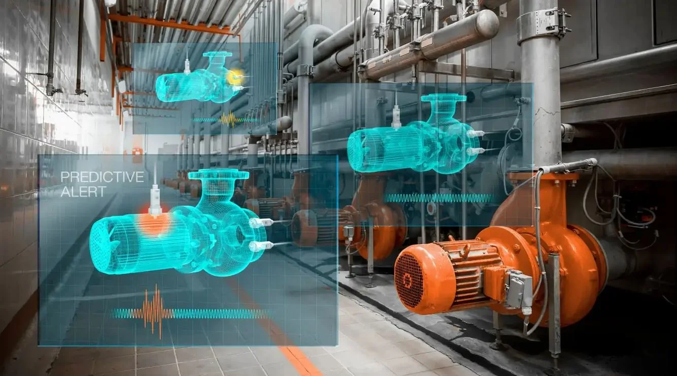
From Point Clouds to Predictive Intelligence
At the center of this transformation is reality capture—the process of creating digital representations of physical environments using tools like drones, laser scanners, and photogrammetry. These devices gather rich spatial data that, once processed, becomes the backbone for everything from 3D models to immersive digital twins.
Digital twins—virtual counterparts of real-world assets—are becoming essential in industries like energy, utilities, and construction. But to build one that’s truly useful, you need a bedrock of accurate, timely data. That’s where reality capture shines. It fills in the gaps left by blueprints and aging GIS systems and provides the level of detail needed to make real-time decisions.
In a utility context, for example, drones can scan transmission towers or substations in minutes—capturing centimeter-accurate point clouds that feed into a digital twin. Once inside that environment, AI can analyze vegetation encroachment, thermal anomalies, or structural shifts, and recommend preemptive actions before a problem escalates into downtime or danger.
Surveying Meets the Machine Age
Despite the rise of automation, skilled professionals remain critical. Surveyors and engineers are the interpreters of this complex digital-physical interface. They understand the nuance behind the numbers—the context behind the scan. Increasingly, they’re not just collecting data but curating and operationalizing it.
In the past, survey-grade accuracy required painstaking fieldwork. Today, that same accuracy is achievable with handheld photogrammetry units or LiDAR-equipped UAVs. When paired with AI-enhanced processing, field data can be uploaded and automatically turned into high-precision models in hours rather than days.
This shift is democratizing advanced mapping and modeling. Smaller enterprises that once lacked access to such technologies can now plug into a cloud-based geospatial ecosystem, leveling the playing field for energy cooperatives, regional utilities, and municipal infrastructure providers.
AI as the Analyst and Accelerator
Artificial intelligence (AI) is accelerating workflows once considered too complex or slow to scale. With digital twins, AI is often the engine that turns static data into actionable insight.
For example, in electrical grid operations, AI can sift through thousands of data points—from real-time data to geospatial scans—to detect early warning signs of failure. It can simulate weather scenarios of a power plant or model the wear-and-tear on utility poles across a region.
More impressively, AI is helping organizations mine “dark data”—previously inaccessible or siloed infrastructure records—and integrate it into current models. This unlocks historical insights and allows engineers to build a more holistic view of their assets, from as-built plans to current field conditions.
Building a Bridge Between Disciplines
One of the most impactful aspects of this evolution is how it's dissolving the silos between surveying, engineering, GIS, and operations.
In traditional projects, data collected by surveyors often had to be manually interpreted and translated for engineers, then separately used by operations teams. Now, with digital twins acting as shared visual platforms—and AI providing context-aware analysis—everyone works from the same source of truth. A surveyor can scan a substation, an engineer can overlay CAD designs onto the scan, and a utility operator can run predictive maintenance simulations—all within the same digital environment.
This integrated workflow not only improves accuracy and speeds up project timelines, but also reduces costly miscommunications and rework.
Practical Use Cases in Energy and Utilities
Here’s where the theory becomes reality:
Utility Pole Inspections: UAVs and mobile mapping systems capture high-resolution imagery and LiDAR data. AI algorithms detect defects, measure clearances, and flag hazards. These inputs update a digital twin that planners and field crews can access remotely.
Substation Design and Upgrades: Engineers use digital twins generated from reality capture to plan retrofits—even without visiting a site. AI can simulate load scenarios and detect clashes before construction begins.
Pipeline Monitoring: Remote sensing and reality capture data can be combined with digital twin models to assess structural integrity and environmental risk, particularly in remote or hazardous areas.
Asset Management: AI identifies maintenance priorities based on usage patterns, environmental exposure, and real-time monitoring, helping teams optimize spending and improve uptime.
The Road Ahead: Smarter Infrastructure, Not Just Smarter Tech
The fusion of reality capture, AI, and digital twins is more than a tech trend—it’s a strategic advantage for industrial enterprises facing increasing demands for resilience, efficiency, and sustainability.
Utilities are already leveraging this convergence to improve grid reliability, reduce emissions, and manage aging infrastructure more effectively. Energy companies are using it to streamline capital projects and meet ESG goals. And across the board, traditional surveying is evolving into a more multidisciplinary, data-driven profession.
As the next wave of technologies—like edge AI, quantum sensors, and more intuitive 3D interfaces—enters the field, the challenge won’t be just capturing data, but putting it to work. Those who can bridge the physical and digital worlds with speed and accuracy will lead the charge.